The smoke reached Delhi in late April 2024. Not factory pollution or crop burning this time. Uttarakhand was burning. Five people died in those flames. Another 1,500 hectares of forest turned to ash. Fire guards ran through valleys with empty pockets and broken equipment, chasing fires that moved faster than their legs could carry them. By the time someone spotted smoke and called it in, flames had already claimed entire hillsides.
But 2,000 kilometers away in Alabama, something different happened. A fire burned through 120 acres near Castleberry, unreported to any official. Nobody on the ground knew it existed. Yet within minutes, thermal maps pinpointing exact flame locations appeared on firefighters’ phones. They knew where to cut fire breaks, where flames burned hottest, which direction the fire would travel next. The difference? Eyes in the sky that see heat signatures invisible to humans, connected to satellites that transmit data faster than smoke can rise.
When Mountains Burn
Walk through an Uttarakhand forest in March. Your feet crunch through a carpet of dried pine needles, sometimes ankle-deep. Strike a match and the whole forest floor could light up. Chir pine dominates these landscapes. The trees laugh at fire. Thick bark protects their trunks while everything around them burns. Then they drop more needles, reload the fuel, wait for next season.
Between November 2023 and June 2024, Uttarakhand recorded 11,256 fire incidents across 11 of its 13 districts. Forest fire frequency from February to late April 2024 showed more than two-fold increase over the same period in 2023, per satellite data (7,122 vs. 2,714 alerts). In late April 2024 alone (up to April 28), the state logged 4,543 fire alerts, the highest nationwide
Traditional detection in mountain terrain works like this: someone in a valley spots smoke on a ridge. They walk to a phone. Make a call. Forest department sends a team. By the time boots reach burning ground, what started as manageable has become catastrophic. Hours matter when you’re fighting fire. Minutes matter more.
Alabama Gets Minutes, Uttarakhand Gets Hours
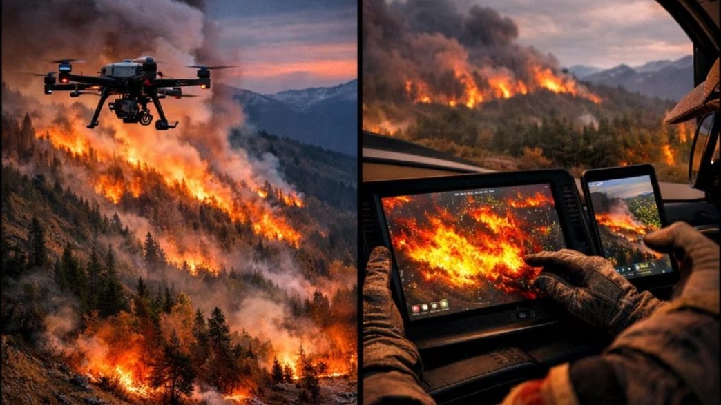
NASA’s AVIRIS-3 sensor flew over Alabama wildfires in March 2025, capturing data across shortwave infrared wavelengths (up to 2,500 nm) invisible to humans. Processed images displayed yellow/orange for the hottest flames, red for cooler burns, and dark red/brown for scorched areas—delivered in near real-time via satellite internet.
The sensor processed data aboard the aircraft. What normally takes days happened in minutes. Satellite internet beamed images to ground crews while the plane still flew. At Mount Vernon, firefighters used these thermal maps to position fire breaks. They stopped flames 100 feet from four buildings.
During March 2025, AVIRIS-3 mapped 13 wildfires across Alabama, Mississippi, Florida, and Texas. Spotted dozens of hot spots. All in real time. Ethan Barrett from Alabama Forestry Commission called the Fire 2400 nm Quicklook the crew favorite. Seeing wildfire outlines from above showed exactly where to send bulldozers. Two days after Castleberry, the sensor caught another fire 2.5 kilometers southwest of Perdido. Thermal maps revealed the hot spot sat inside the fire’s perimeter, so crews shifted resources to Mount Vernon instead.
The technology doesn’t wait for smoke to become visible. It sees heat signatures through haze. Identifies smoldering before flames appear. Sends coordinates to phones faster than radio dispatches.
Virtual Fires Test Real Strategies
NASA’s Wildfire Digital Twin project creates fire simulations at 10 to 30 meters per pixel. Current global models work at roughly 10 kilometers per pixel. That’s two orders of magnitude improvement. These high-resolution models generate in minutes, not hours.
Milton Halem runs the project from University of Maryland Baltimore County. His team designed the system to run on tablets without internet. Firefighters in remote locations can model fire behavior on portable devices, testing suppression strategies before deploying crews.
The system builds on NASA’s Unified Weather Research and Forecasting model plus WRF-SFIRE. These simulate wind speed and cloud cover, creating foundations for digital twin functionality. In October, the team joined FireSense’s field campaign in Utah, watching smoke travel more than 10 miles during a controlled burn using a ceilometer. That data now trains software to track plumes more accurately, particularly particles smaller than 2.5 micrometers that penetrate deep into lungs and bloodstreams.
Through August 2023, boreal wildfires accounted for 25% of all global CO2 emissions. High latitudes warm faster than the rest of the planet. While most regions gained one degree Celsius since pre-industrial times, boreal zones warmed over two degrees. Longer summers mean longer fire seasons. More fuel, more heat, more flames.
Digital twins let incident commanders ask “what if” questions. What happens if we cut a fire line along this ridge? How will smoke move if wind shifts northeast? Which villages need evacuation if flames jump this creek? The software runs scenarios in minutes, showing probable outcomes for different decisions.
Swarms That Think Together
Picture three suitcase-sized units placed at different locations, each outside the others’ line of sight. They share flight plans through mesh radio networks. NASA tested this in November 2024 at Ames Research Center. Researchers intentionally submitted conflicting flight plans, flew drones outside approved areas. The Portable Airspace Management System caught every violation.
At Monterey Bay Academy Airport in Watsonville, California, engineers flew a winged drone with vertical takeoff capability. It established communications relay to three different PAMS units while two smaller drones flew nearby. The system shared aircraft locations, weather updates, simulated fire data. Alerted pilots to conflicts and boundary breaches.
High-altitude platforms become airborne command centers, directing lower-altitude drones for targeted operations. A separate NASA project develops AI-enabled drone swarms for fire detection and mapping. Edge distributed AI models segment ignited areas, sharing information fleet-to-fleet and platform-to-fleet. This reduces communication burden while computing fire growth indicators.
The mesh radio network connecting larger drones with smaller ones and multiple ground units creates self-healing communications. One drone’s battery dies? Another takes its position. Communications drop? The network reroutes. It’s coordination without constant human oversight.
Current aerial firefighting stops when smoke reduces visibility. Pilots cannot risk flying into terrain or colliding with other aircraft. This means grounding during nights and heavy smoke, exactly when fires spread most aggressively. Ground-operated drones overcome this limitation.
Minutes That Save Lives
Response time determines outcomes more than equipment sophistication. Moderately accurate predictions delivered in ten minutes have more value than perfect data arriving in two hours. Drones excel at delivering timely, actionable intelligence exactly when decisions must be made.
Technology requires trained operators who understand both drone systems and local fire behavior. Infrastructure must exist to maintain equipment, process data, coordinate response. Communities need education about fire risk and prevention.
But when flames ignite in pine forests during dry seasons, having sensors that see invisible heat signatures changes everything. AI that predicts fire movement patterns. Digital twins that test strategies before committing resources. Swarms that coordinate with machine efficiency.
The gap between ignition and response has always determined how much forest burns, how many lives are lost, how much damage occurs. NASA’s drone technology compresses that gap from hours to minutes. From “we think there might be a fire somewhere in that valley” to “flames are burning at these exact coordinates with this intensity moving in this direction.”
When Technology Meets Mountains
The five people who died in Uttarakhand’s 2024 fire season cannot be brought back. The 1,500 hectares of forest cannot be unburned. But the 11,256 fires that season represent 11,256 chances for earlier detection. Each detected fire becomes data that trains algorithms. Each successful containment proves the approach works.
Alabama proved the technology works. Castleberry proved it. Mount Vernon proved it. Perdido proved it. The question is not whether these systems can save forests and lives. The question is how quickly we deploy them, how well we train operators, how thoroughly we integrate them into existing response systems.
Because next November, when the first pine needles dry and someone’s careless match or deliberate torch touches them, Uttarakhand will either have eyes in the sky that see heat before flames appear, or it will have the same system that gave those five people no warning at all.
Each saved forest, each protected village, each preserved life justifies the investment in turning artificial intelligence into real firefighting capability. The technology exists. It flies. It processes data in minutes. It sends thermal maps to phones. The only thing missing is political will to deploy it where mountains burn and people die waiting for help that arrives too late.